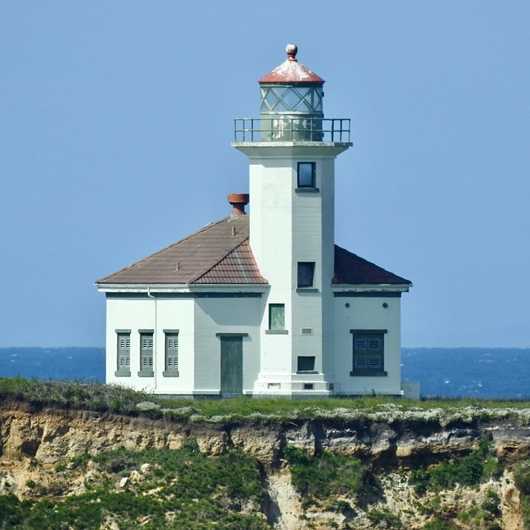
Cape Arago

Chiefs Island, part of Cape Arago, was first lit in 1866, only 7 years after the state of Oregon was admitted to the Union. It was the second light on the state's shoreline, after the original lighthouse at Umpqua River, which was lit 9 years earlier.
The first lighthouse on the island was an octagonal steel tower with a skeletal lower portion and enclosed watch room, featuring two gallery levels. The enclosed section was accessed via a spiral staircase in the centre of the structure. In 1894, Congress made funds available to upgrade the light station in several ways, but most noticeably the tower was encased in an outer skin of brick, giving it more protection and indirectly giving it a more traditional appearance. These improvement works also included the construction of a wood frame duplex for keepers' accomodation.
A long wooden trestle bridge gave access to the island; however its exposed location was prone to erosion and strong high tides which frequently damaged and even destroyed the bridge on several occasions. By 1909, a second lighthouse had to be constructed, as the original was becoming increasingly at risk from erosion.
The second lighthouse, an octagonal wooden tower rising from a fog horn and engine room, soon met the same fate and was replaced by the third and current lighthouse in 1934, making it one of the last substantial lighthouses to be built in the state of Oregon. This newer tower, built of concrete, better suited to the exposed location.
Quite remarkably, despite the risks posed by erosion, the original brick-lined tower remained mostly complete until 1936 when it was blown up by dynamite. The second lighthouse was demolished in 1934, leaving only the fog horn building that stood at its base, which was resited and used as the keeper's offices until it too was demolished in the 1960s.
Electrified from the outset, this latest incarnation of Cape Arago lighthouse was converted to automatic operation in 1966. Originally it had used the octagonal lantern room of the second lighthouse, but at some point this was replaced with a lantern more typical of later lighthouse designs, using curved glass and diagonal astragals.
The lighthouse was deactivated on January 1st 2006, and in 2013 it and the ownership of the surrounding land was transferred to the Confederated Tribes of Coos, Lower Umpqua, and Siuslaw Indians. As such, this light can be difficult to view at close range due to its location within reservation land, however there is a good viewpoint, albeit somewhat distant, found at Lighthouse Lookout, a lay-by on Highway 540, west of Sunset Beach and Norton Gulch.
